Supercell Thunderstorms Explained

A large, organized thunderstorm with a rotating updraft, often producing severe weather such as tornadoes, hail, and heavy rain.

Supercells are distinguished from other thunderstorms by their sustained and rotating updrafts, known as mesocyclones. These storms can persist for hours and are capable of producing severe weather conditions over wide areas.

Diagram showing the structure of a supercell thunderstorm
Anatomy of a supercell thunderstorm

Key Features of a Supercell:

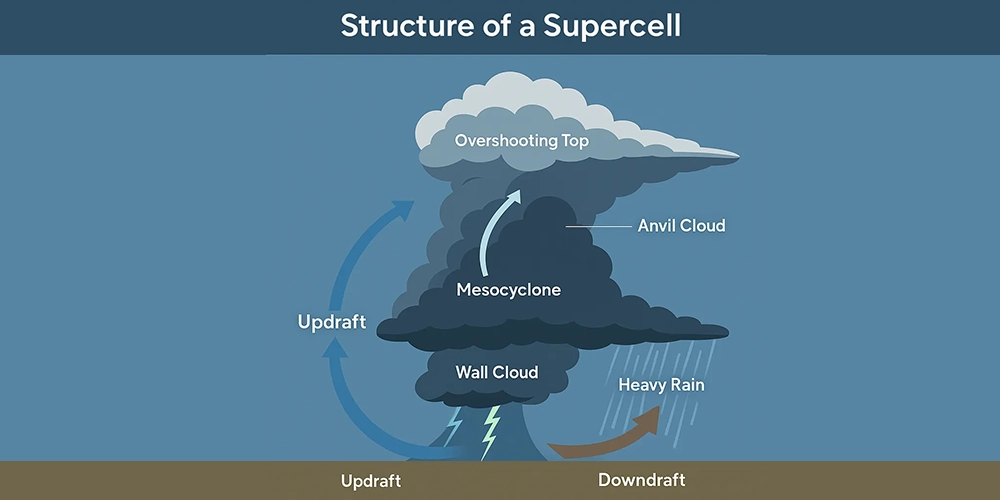
  • Mesocyclone: A rotating column of rising air, visible on radar as a strong velocity couplet.
  • Anvil Cloud: A flat, spreading cloud top that often extends downwind due to high-altitude winds.
  • Overshooting Top: A dome-like bulge above the anvil, indicating intense upward motion.
  • Wall Cloud: A lowering of the cloud base that can signal tornado development.

Types of Supercells:

  1. Classic Supercell: Produces all hazards—hail, wind, and tornadoes.
  2. Low-Precipitation (LP) Supercell: Minimal rain but high wind and hail potential.
  3. High-Precipitation (HP) Supercell: Heavy rainfall, reduced visibility, and flood risk.

Formation Conditions:

Supercells form when warm, moist air near the surface rises into colder, drier air aloft, in an environment with:

  • Strong vertical wind shear
  • High instability (CAPE)
  • Lift from fronts or drylines

Why It Matters:

Supercells are responsible for most significant tornadoes and large hail events. Their long lifespan and violent behavior make them a focus for both research and forecasting efforts. Understanding how supercells behave is key to issuing timely warnings and reducing damage.

Buluttan’s Forecasting Advantage:

With AI-enhanced atmospheric modeling, Buluttan detects the conditions favorable for supercell formation earlier and more accurately. Our hyper-local alerts are designed to help cities, transportation systems, and emergency teams respond faster and more effectively.

Schedule a Demo Today

A new era is starting with fundamentally new forecasting with unprecedented precision!

Contact Us

Glossary

The large-scale movement of air that distributes heat and moisture around the Earth, influencing weather patterns and climatic...

Condensation pressure deficit refers to the difference between the actual vapor pressure and the saturation vapor pressure...

A condition in which the stratification of the atmosphere depends on both air temperature and pressure, and where surfaces...

The belt between 50-70 ° N and S latitudes in the Northern and Southern Hemispheres, adjacent to the Polar Region. Although...

Precipitation in the form of small balls or lumps of ice that form in thunderstorm updrafts and fall to the ground.

Perhaps you have come across them, maybe you are seeing them for the first time. These clouds, known as wave clouds, resemble...

Conduction is the transfer of heat or electricity through a material without the material itself moving. This occurs when...

A thin, white cloud layer that is intertwined or separate, arranged in regular order, and does not cast a shadow.

A storm characterized by the presence of lightning and its acoustic effect on the Earth's atmosphere known as thunder.

Thermodynamic changes occurring within a system without any exchange of heat with the surroundings. In the atmosphere, changes...

Istanbul 9°CAnkara 7°CIzmir 18°CHow is your weather?